Filter
95
Filtered Results: 95
Text search:
ArcGIS
Featured
Recommendations
3
New Publications
16
Language
Document type
Studies & Reports
37
No document type
29
Strategic & Response Plan
12
Guidelines
10
Manuals
3
Brochures
2
Training Material
1
Fact sheets
1
Countries / Regions
Global
6
Bangladesh
6
Kenya
5
Latin America and the Carribbean
5
India
5
Nepal
4
Ukraine
3
Rwanda
3
Africa
3
Venezuela
3
Myanmar / Burma
3
Malawi
2
Tanzania
2
Middle East and North Africa
2
Western and Central Europe
2
South Africa
2
Brazil
2
Sri Lanka
2
Namibia
2
Liberia
2
Ecuador
2
Colombia
1
El Salvador
1
Turkey
1
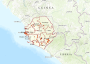
Sierra Leone
1
Togo
1
Chile
1
Cameroon
1
Syria
1
Afghanistan
1
Peru
1
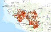
Guinea
1
Congo, Democratic Republic of
1
Paraguay
1
North America
1
United Kingdom
1
Bolivia
1
Argentina
1
Lebanon
1
Uganda
1
Eastern Europe
1
Bhutan
1
Zambia
1
South Sudan
1
Pakistan
1
Authors & Publishers
Publication Years
Category
Countries
47
Clinical Guidelines
8
Key Resources
4
Public Health
3
Capacity Building
1
Women & Child Health
1
Toolboxes
Planetary Health
10
NTDs
9
COVID-19
5
Pharmacy
5
Natural Hazards
3
Ebola & Marburg
3
Caregiver
3
NCDs
3
Conflict
3
Health Financing Toolbox
2
Malaria
2
AMR
2
Rapid Response
1
Mental Health
1
HIV
1
TB
1
Global Health Education
1

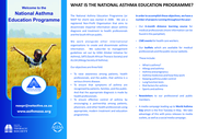
The National Asthma Education Programme (or NAEP for short) was started in 2008. We are a registered Non-Profit Organisation that aims to disseminate impartial information about asthma diagnosis and treatment to health professionals and the South African public.
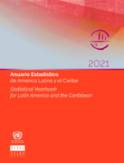
The Statistical Yearbook for Latin America and the Caribbean of ECLAC presents a set of basic statistics on the economic, sociodemographic and environmental situation of the region during a specific time period.
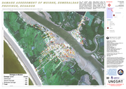
This map illustrates satellite-detected, potential damaged structures in Muisne, Esmeraldas Province, Ecuador. The analyzed area is located approximately 30 km north of the 16 April 2016 Muisne earthquake mainshock epicenter. This analysis is carried out using Pléiades satellite image acquired 20 A...
Analysis with WorldView-3 Data Acquired 07 March 2015
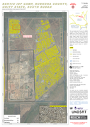
This map illustrates the IDP camp at the UNMISS Protection of Civilian (PoC) area adjacent to the UNMISS base in Bentiu, Rubkona County, Unity State, South Sudan. Using high-resolution optical satellite imagery collected by the WorldView-3 sat...
PLoS Med 15(7): e1002615. https://doi.org/10.1371/journal. pmed.1002615
The authors conduct an integrated survey of Antimicrobial Resistant Organisms (AMR) in drinking water, wastewater and surface water in three settings in Bangladesh: rural households, rural poultry farms, and urban food markets. Results show that untreated water discharged from rural households, poul...
WHO recently conducted a survey to assess the availability and cost of a national tracer list of essential medicines in the outpatient sector in Ukraine using a new collection tool – the WHO Essential Medicines and Health Products Price and Availability Monitoring Mobile Application. This tool fac...
The Government recognizes the critical role of the built environment in addressing climate change and environmental degradation. To this end, it has identified and empowered the Kenya Building Research Centre to champion and coordinate the government’s green building agenda in relation to climate ...
Starting on 24 February 2022, a large-scale armed conflict in Ukraine triggered an unprecedented humanitarian crisis across the country, characterised, among other elements, by the displacement of a significant proportion of the Ukrainian population.
As early as April 2022, the International Organi...
BackgroundClimate change is one of the great challenges of our time. The consequences of climate change on exposed biological subjects, as well as on vulnerable societies, are a concern for the entire scientific community. Rising temperatures, heat waves, floods, tornadoes, hurricanes, droughts, fir...
WHO published the first COVID-19 Strategic Response and Preparedness Plan (SPRP) on 3 February, 2020. This report highlights the main points of progress that were made up to 30 June 2020 under the three objectives outlined in the SPRP: scaling up international coordination and support; scaling up co...

Taenia saginata is a zoonotic tapeworm that is of economic importance in countries where cattle are kept. The parasite is transmitted from human tapeworm carriers (taeniosis) to bovines (cysticercosis) by excretion of eggs or proglottids containing eggs into the environment via the stool. Bovines ca...
The Atlas of Palliative Care in the Eastern Mediterranean Region is the first systematic attempt to assess the status of resources, activities, and needs of palliative care in the region. It provides a comparative picture of the current state of palliative care in simple and clear graphics, utilisin...
The World Health Organization (WHO) endorses the use of population-based prevalence surveys for estimating the prevalence of trachoma. In general, the prevalence of TF in children aged 1–9 years and the prevalence of TT in adults aged ≥ 15 years are measured at the same time in any district bein...
The World Health Organization (WHO) endorses the use of population-based prevalence surveys for estimating the prevalence of trachoma. In general, the prevalence of TF in children aged 1–9 years and the prevalence of TT in adults aged ≥ 15 years are measured at the same time in any district bein...
This study aimed to analyze the geographical distribution of coronavirus disease 2019 (COVID-19) and to identify high-risk areas in space and time for the occurrence of cases and deaths in the indigenous population of Brazil. This is an ecological study carried out between 24 March and 26 October 20...