Filter
10
Featured
7
Language
Document type
9
1
Countries
10
1
Authors & Publishers
Publication Years
Category
1
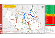
In January 2018, over 10,000 people fled their homes following clashes reported in multiple locations in Jonglei, including Yuai, Pultruk, Payai, Kuer-nyuon, Pieri, Waat and Walgak. Some crossed to
Ethiopia, where 2,300 people registered as refugees in the Gambela region. There were several report
...

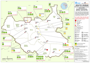
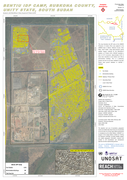
Analysis with WorldView-3 Data Acquired 07 March 2015
This map illustrates the IDP camp at the UNMISS Protection of Civilian (PoC) area adjacent to the UNMISS base in Bentiu, Rubkona County, Unity State, South Sudan. Using high-resolution optical satellite imagery collected by the WorldView-3 sat
...