Filter
2184
Text search:
damage
assessment
Featured
268
637
Language
2130
49
37
28
26
18
12
7
5
5
4
4
3
3
3
3
3
3
3
3
3
2
2
2
2
2
2
2
2
2
2
2
2
2
2
2
2
1
1
1
1
1
1
1
1
1
1
1
1
1
1
1
1
1
1
1
Document type
1137
345
342
160
76
61
30
18
5
3
3
3
1
Countries
121
101
64
53
47
45
38
34
34
32
32
32
31
30
27
27
25
22
22
21
21
19
16
16
14
14
13
12
12
11
10
10
9
9
9
8
7
7
7
7
6
6
6
6
5
5
5
5
5
4
4
4
4
4
4
4
4
4
3
3
3
3
3
2
2
2
2
2
2
2
2
2
2
2
2
2
2
2
2
2
2
2
2
2
2
2
1
1
1
1
1
1
1
1
1
1
1
1
1
1
1
1
1
1
1
1
1
1
1
1
1
1
Authors & Publishers
286
86
62
60
43
39
36
27
20
19
19
14
13
13
12
12
12
12
11
11
11
11
10
10
10
9
8
8
8
8
8
7
7
7
7
7
7
7
7
6
6
6
6
6
6
6
6
6
5
5
5
5
5
5
5
5
5
5
5
5
4
4
4
4
4
4
4
4
4
4
4
4
4
4
4
4
4
4
4
4
4
4
4
3
3
3
3
3
3
3
3
3
3
3
3
3
3
3
3
3
3
3
3
3
3
3
3
3
3
3
3
3
3
3
3
3
3
3
3
3
3
3
3
3
3
3
3
3
3
3
3
3
3
3
3
2
2
2
2
2
2
2
2
2
2
2
2
2
2
2
2
2
2
2
2
2
2
2
2
2
2
2
2
2
2
2
2
2
2
2
2
2
2
2
2
2
2
2
2
2
2
2
2
2
2
2
2
2
2
2
2
2
2
2
2
2
2
2
2
2
2
2
2
2
2
2
2
2
2
2
2
2
2
2
2
2
2
2
2
2
2
2
2
2
2
2
2
2
2
2
2
2
2
2
2
2
2
2
2
2
2
2
2
2
2
2
2
2
2
2
2
2
2
2
2
2
2
2
2
2
2
2
2
2
2
2
2
2
2
2
2
1
1
1
1
1
1
1
1
1
1
1
1
1
1
1
1
1
1
1
1
1
1
1
1
1
1
1
1
1
1
1
1
1
1
1
1
1
1
1
1
1
1
1
1
1
1
1
1
1
1
1
1
1
1
1
1
1
1
1
1
1
1
1
1
1
1
1
1
1
1
1
1
1
1
1
1
1
1
1
1
1
1
1
1
1
1
1
1
1
1
1
1
1
1
1
1
1
1
1
1
1
1
1
1
1
1
1
1
1
1
1
1
1
1
1
1
1
1
1
1
1
1
1
1
1
1
1
1
1
1
1
1
1
1
1
1
1
1
1
1
1
1
1
1
1
1
1
1
1
1
1
1
1
1
1
1
1
1
1
1
1
1
1
1
1
1
1
1
1
1
1
1
1
1
1
1
1
1
1
1
1
1
1
1
1
1
1
1
1
1
1
1
1
1
1
1
1
1
1
1
1
1
1
1
1
1
1
1
1
1
1
1
1
1
1
1
1
1
1
1
1
1
1
1
1
1
1
1
1
1
1
1
1
1
1
1
1
1
1
1
1
1
1
1
1
1
1
1
1
1
1
1
1
1
1
1
1
1
1
1
1
1
1
1
1
1
1
1
1
1
1
1
1
1
1
1
1
1
1
1
1
1
1
1
1
1
1
1
1
1
1
1
1
1
1
1
1
1
1
1
1
1
1
1
1
1
1
1
1
1
1
1
1
1
1
1
1
1
1
1
1
1
1
1
1
1
1
1
1
1
1
1
1
1
1
1
1
1
1
1
1
1
1
1
1
1
1
1
1
1
1
1
1
1
1
1
1
1
1
1
1
1
1
1
1
1
1
1
1
1
1
1
1
1
1
1
1
1
1
1
1
1
1
1
1
1
1
1
1
1
1
1
1
1
1
1
1
1
1
1
1
1
1
1
1
1
1
1
1
1
1
1
1
1
1
1
1
1
1
1
1
1
1
1
1
1
1
1
1
1
1
1
1
1
1
1
1
1
1
1
1
1
1
1
1
1
1
1
1
1
1
1
1
1
1
1
1
1
1
1
1
1
1
1
1
1
1
1
1
1
1
1
1
1
1
1
1
1
1
1
1
1
1
1
1
1
1
1
1
1
1
1
1
1
1
1
1
1
1
1
1
1
1
1
1
1
1
1
1
1
1
1
1
1
1
1
1
1
1
1
1
1
1
1
1
1
1
1
1
1
1
1
1
1
1
1
1
1
1
1
1
1
1
1
1
1
1
1
1
1
1
1
1
1
1
1
1
1
1
1
1
1
1
1
1
1
1
1
1
1
1
1
1
1
1
1
1
1
1
1
1
1
1
1
1
1
1
1
1
1
1
1
1
1
1
1
1
1
1
1
1
1
1
1
1
1
1
1
1
1
1
1
1
1
1
1
1
1
1
1
1
1
1
1
1
1
1
1
1
1
1
1
1
1
1
1
1
1
1
1
1
1
1
1
1
1
1
1
1
1
1
1
1
1
1
1
1
1
1
1
1
1
1
1
1
1
1
1
1
1
1
1
1
1
1
1
1
1
1
1
1
1
1
1
1
1
1
1
1
1
1
1
1
1
1
1
1
1
1
1
1
1
1
1
1
1
1
1
1
1
1
1
1
1
1
1
1
1
1
1
1
1
1
1
1
1
1
1
1
1
1
1
1
1
1
1
1
1
1
1
1
1
1
1
1
1
1
1
1
1
1
1
1
1
1
1
1
1
1
1
1
1
1
1
1
1
1
1
1
1
1
1
1
1
1
1
1
1
1
1
1
1
1
1
1
1
1
1
1
1
1
1
1
1
1
1
1
1
1
1
1
1
1
1
1
1
1
1
1
1
1
1
1
1
1
1
1
1
1
1
1
1
1
1
1
1
1
1
1
1
1
1
1
1
1
1
1
1
1
1
1
1
1
1
1
1
1
1
1
1
1
1
1
1
1
1
1
1
1
1
1
1
1
1
1
1
1
1
1
1
1
1
1
1
1
1
1
1
1
1
1
1
1
1
1
1
1
1
1
1
1
1
1
1
1
1
1
1
1
1
1
1
1
1
1
1
1
1
1
1
1
1
1
1
1
1
1
1
1
1
1
1
1
1
1
1
1
1
1
1
1
1
1
1
1
1
1
1
1
1
1
1
1
1
1
1
1
1
1
1
1
1
1
1
1
1
1
1
1
1
1
1
1
1
1
1
1
1
1
1
1
1
1
1
1
1
1
1
1
1
1
1
1
1
1
1
1
1
1
1
1
1
1
1
1
1
1
1
1
1
1
1
1
1
1
1
1
1
1
1
1
1
1
1
1
1
1
1
1
1
1
1
1
1
1
1
1
1
1
1
1
1
1
1
1
1
1
1
1
1
1
1
1
1
1
1
1
1
1
1
1
1
1
1
1
1
1
1
1
1
1
1
1
1
1
1
1
1
1
1
1
1
1
1
1
1
1
1
1
1
1
1
1
1
1
1
1
1
1
1
1
1
1
1
1
1
1
1
1
1
1
1
1
1
1
1
1
1
1
1
1
1
1
1
1
1
1
1
1
1
1
1
1
1
1
1
1
1
1
1
1
1
1
1
1
1
1
1
1
1
1
1
1
1
1
1
1
1
1
1
1
1
1
1
1
1
1
1
1
1
1
1
1
1
1
1
1
1
1
1
1
1
1
1
1
1
1
1
1
1
1
1
1
1
1
1
1
1
1
1
1
1
1
1
1
1
1
1
1
1
1
1
1
1
1
1
1
1
1
1
1
1
1
1
1
1
1
1
1
1
1
1
1
1
1
1
1
1
1
1
1
1
1
1
1
1
1
1
1
1
1
1
1
1
1
1
1
1
1
1
1
1
1
1
1
1
1
1
1
1
1
1
1
1
1
1
1
1
1
1
1
1
1
1
1
1
1
1
1
1
1
1
1
1
1
1
1
1
1
1
1
1
1
1
1
1
1
1
1
1
1
1
1
1
1
1
1
1
1
1
1
1
1
1
1
1
1
1
1
1
1
1
1
1
1
1
1
1
1
1
1
1
1
1
1
1
1
1
1
1
1
1
1
1
1
1
1
1
1
1
1
1
1
1
1
1
1
1
1
1
1
1
1
1
1
1
1
1
1
1
1
1
1
1
1
1
1
1
1
1
1
1
1
1
1
1
1
1
1
1
1
1
1
1
1
1
1
1
1
1
1
1
1
1
1
1
1
1
1
1
1
1
1
1
1
1
1
1
1
1
1
1
1
1
1
1
1
1
1
1
1
1
1
1
1
1
1
1
1
1
1
1
1
1
1
1
1
1
1
1
1
1
1
1
1
1
1
1
1
1
1
1
1
1
1
1
1
1
1
1
1
1
1
1
1
1
1
1
1
1
1
1
1
1
1
1
1
1
1
1
1
1
1
1
1
1
1
1
1
1
1
1
1
1
1
1
1
1
1
1
1
1
1
1
1
1
1
1
1
1
1
1
1
1
1
1
1
1
1
1
1
1
1
1
1
1
1
1
1
1
1
1
1
1
1
1
1
1
1
1
1
1
1
1
1
1
1
1
1
1
1
1
1
1
1
1
1
1
1
1
1
1
1
1
1
1
1
1
1
1
1
1
1
1
1
1
1
1
1
1
1
1
Publication Years
594
1297
272
20
1
Category
707
260
207
108
105
57
37
Toolboxes
164
154
135
134
120
94
79
66
65
57
54
52
50
49
44
40
35
34
28
17
13
11
10
8
5
3
2
Damage Assessment of Muisne, Esmeraldas, Province, Ecuador (22 Apr 2016)
UNOSAT, International Charter Space and Major Disasters
(2016)
C1
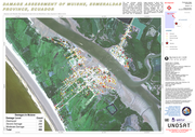
This map illustrates satellite-detected, potential damaged structures in Muisne, Esmeraldas Province, Ecuador. The analyzed area is located approximately 30 km north of the 16 April 2016 Muisne earthquake mainshock epicenter. This analysis is carried out using Pléiades satellite image acquired 20 A
...
pril 2016 and a WorldView-3 image acquired 12 March 2016. UNITAR-UNOSAT identified 450 potentially damaged structures of which 139 are destroyed, 206 severely damaged, and 105 moderately damaged. This map illustrates satellite-detected, potential damaged structures in Muisne, Esmeraldas Province, Ecuador. The analyzed area is located approximately 30 km north of the 16 April 2016 Muisne earthquake mainshock epicenter. This analysis is carried out using Pléiades satellite image acquired 20 April 2016 and a WorldView-3 image acquired 12 March 2016. UNITAR-UNOSAT identified 450 potentially damaged structures of which 139 are destroyed, 206 severely damaged, and 105 moderately damaged. This is a preliminary analysis and not yet been validated in the field. Please send ground feedback to UNITAR-UNOSAT.
more

This information can be used to assess the extent of the damage and the needs of affected communities. Information should be gathered on the extent of damage to infrastructure, housing, and public f
...
acilities such as hospitals, schools, and water systems. This information can be used to prioritize the response effort and to direct resources to where they are most needed.
In addition to gathering information on the extent of damage, it is also important to gather information on the number of people affected and the types of assistance they need. This may include information on the number of people who are injured, displaced, or in need of shelter, food, and water. This information can be used to prioritize the response effort and to ensure that assistance is provided in a way that meets the specific needs of affected communities.
more
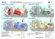
On November 9, the Russian military announced a full retreat of all their forces from the right bank of Dnipro River; by November 11, 41 settlements, including Kherson city, were de-occupied by Ukrainian forces. Civilians who live in these areas have endured months of combat and occupation. Services
...
have been interrupted or severely disrupted due to damage or destruction of facilities and infrastructure through combat actions, looting of the majority of the valuable assets by the retreating Russian troops, and dispersion of the people rendering said services.
more
The building damage assessment, conducted between March 2010 and February 2011 by the Government of Haiti and the United Nations system, showed that more than 400,000 buildings were damaged or destr
...
oyed, of which approximately 218,000 could be occupied without repairs (green category), 105,000 were damaged but could be repaired (yellow category), and 80,000 were severely damaged and remained uninhabitable (red category).
The destruction of buildings and infrastructure generated a huge amount of debris, estimated at 10 million cubic meters, blocking streets and land in affected areas. In the absence of a national debris management strategy, debris could, thus, be cleared and disposed of in an uncontrolled manner, hindering relief, recovery and reconstruction activities.
more
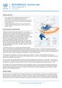
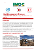
Initial reports indicate significant damage to Beira and surrounding areas, including destroyed houses.
• Sofala, Manica, Zambezia and Inhambane provinces have been hardest hit by the cyclone’s path and the preceding tropical depression.
�
...
�� An inter-agency assessment team, led by the National Institute of Disaster Management’s (INGC) Director, is on ground in Beira
more
This module carries pre-training entry level assessment as well as hands on exercise manual on Geographic Information Systems, Remote Sensing, Geographic Positioning System (GPS) and some applications of these technologies on Disaster Risk Managemen
...
t (DRM) especially for hazard mapping, monitoring and risk assessment module as well as the damage assessment module. Practical manual developed using open source products like Quantum GIS , RStudio, Google Earth Pro and Google Earth Engine.
This module can also can be used by other training facilitators, non-technical professionals and selflearners as well. However, it is strongly recommended that training participants and self-learners already have some basic knowledge of Computer Basic, Geoinformatics and disaster management.
No publication year indicated.
Original file: 30,5 MB more

This module carries pre-training entry level assessment as well as hands on exercise manual on Geographic Information Systems, Remote Sensing, Geographic Positioning System (GPS) and some applications of these technologies on Disaster Risk Managemen
...
t (DRM) especially for hazard mapping, monitoring and risk assessment module as well as the damage assessment module. Practical manual developed using open source products like Quantum GIS , RStudio, Google Earth Pro and Google Earth Engine.
This module can also can be used by other training facilitators, non-technical professionals and selflearners as well. However, it is strongly recommended that training participants and self-learners already have some basic knowledge of Computer Basic, Geoinformatics and disaster management.
No publication year indicated.
Original file: 29,5 MB more
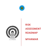
The need for a roadmap for risk assessment stemmed from the lack of standardised and systematic effort to national risk assessment effort to date. The road map details the process, activities necess
...
ary for each step and the availability and accessibility of technical and financial resources, and coordination mechanisms for the implementation f a national risk assessment.
more

to identify measure and decide how to meet the humanitarian needs of disaster-affected community
Community Assessment For Public Health Emergency Response (Casper) Toolkit; third edition 3.2
recommended
2nd edition
Eight years after Super Typhoon Haiyan, the most destructive storm to ever hit the Philippines, Super Typhoon Rai brought similar torrential rains, violent winds, mudslides, floods and storm surges to central parts of the Philippines, leaving a wide path of destruction and debris in its wake. While
...
not as powerful as Haiyan in terms of wind strength, evidence shows that Rai damaged houses, infrastructure and livelihoods on a comparable scale or in even greater numbers. Most striking, Rai damaged 1.57 million homes, 500,000 more than Haiyan, across 11 of the Philippines 17 regions, with around 180,000-200,000 people still displaced – either still in evacuation centers or staying with friends, family or other temporary housing.
more


Handbook for Disaster Assessment
Laura Ortíz, Omar D. Bello, Liudmila Ortega et al.
Economic Commission for Latin America and the Caribbean (ECLAC),
(2014)
This handbook reflects and updates the work that ECLAC has done in recent decades to establish a methodology for estimating the economic consequences of a disaster, and thus determine the financing required to rebuild and return the affected area to normal. The handbook's third edition strengthens p
...
rocedures for estimating the effects of disasters, for distinguishing between losses and additional costs and systematizing the links that exist between different sectors of the economy
more


This presentation provides an earthquake risk assessment of Mandalay city in Myanmar. It identifies areas of potentially high seismic risk, which will allow national and local authorities to make plans to mitigate the risk, to allocate resources, an
...
d plan for emergency responses accordingly, ultimately leading to a safer community.
more