Filter
10649
Filtered Results: 10649
Text search:
Nature
Featured
Recommendations
959
New Publications
2442
Language
Document type
No document type
5382
Studies & Reports
1984
Guidelines
1524
Manuals
673
Strategic & Response Plan
423
Fact sheets
241
Training Material
225
Situation Updates
73
Resource Platforms
42
Brochures
36
Infographics
26
Online Courses
10
Dashboards/Maps
5
Videos
4
App
1
Countries / Regions
Global
508
India
343
Kenya
203
Latin America and the Carribbean
198
Congo, Democratic Republic of
185
Myanmar / Burma
167
Western and Central Europe
166
South Africa
158
Ethiopia
156
Sierra Leone
145
Africa
144
Nepal
141
Uganda
136
Bangladesh
128
Nigeria
124
Liberia
123
Senegal
120
Syria
117
Brazil
116
Mozambique
105
Indonesia
104
Rwanda
98
Haiti
98
Malawi
95
Tanzania
93
Zambia
90
Burkina Faso
89
Ghana
84
Ukraine
80
Guinea
79
Germany
77
Philippines
72
South–East Asia Region
70
South Sudan
67
Namibia
66
Benin
65
Eastern Europe
65
Colombia
57
Cameroon
57
West and Central Africa
54
Paraguay
51
Central African Republic
51
Zimbabwe
50
Asia
50
Venezuela
49
Russia
47
Mali
43
East and Southern Africa
42
Lesotho
41
Yemen
41
Cambodia
40
Middle East and North Africa
40
Eastern Europe and Central Asia
36
Peru
35
Pakistan
33
Côte d’Ivoire / Ivory Coast
29
Argentina
28
Madagascar
28
Botswana
27
Angola
26
Afghanistan
25
Chile
24
Sudan
24
Eswatini/ Swaziland
24
China
23
Jordan
22
Lebanon
21
Vietnam
21
Somalia
21
Niger
18
Bolivia
18
Ecuador
18
Western Pacific Region
17
Iraq
17
Thailand
16
Turkey
16
USA
16
Chad
16
Sri Lanka
15
North America
13
Tajikistan
12
Laos
12
Guinea-Bissau
12
Burundi
11
Spain
11
El Salvador
10
Togo
10
Moldova
10
Kazakhstan
9
Albania
9
United Kingdom
9
Mexico
8
Iran
8
Portugal
8
Egypt
8
Palestine
8
Honduras
8
Italy
7
France
7
Papua New Guinea
7
Libya
7
North Macedonia
6
Kyrgyzstan
6
Morocco
6
Southern Africa
6
Guatemala
6
Serbia
5
Canada
5
Dominican Republic
5
Saudi Arabia
5
Turkmenistan
5
Jamaica
5
Greece
5
Georgia
5
Bhutan
5
Switzerland
4
Timor Leste/ East Timor
4
Gambia
4
Armenia
4
Tunisia
4
Poland
4
Congo-Brazzaville
3
Malaysia
3
Mongolia
3
Qatar
3
Mauritania
3
Japan
3
Bosnia and Herzegovina
3
Nicaragua
3
Fiji
2
Singapore
2
Estonia
2
Uzbekistan
2
Austria
2
Croatia
2
Lithuania
2
Gabon
2
Mauritius
2
Azerbaijan
2
Belarus
2
Israel
2
Djibouti
2
Romania
2
Cuba
2
North Korea
1
Australia
1
Vanuatu
1
Bulgaria
1
Hungary
1
Ireland
1
Uruguay
1
Denmark
1
Maldives
1
South Korea
1
Algeria
1
Latvia
1
Belize
1
Costa Rica
1
Guyana
1
Panama
1
Authors & Publishers
Publication Years
Category
Countries
3545
Clinical Guidelines
779
Key Resources
742
Women & Child Health
579
Public Health
562
Capacity Building
206
Pharmacy & Technologies
136
Annual Report MEDBOX
3
Toolboxes
COVID-19
986
Mental Health
903
HIV
575
Planetary Health
540
TB
476
Disability
436
NTDs
355
Ebola & Marburg
318
Caregiver
310
Conflict
296
AMR
284
Refugee
252
Natural Hazards
243
Rapid Response
227
Global Health Education
211
Pharmacy
171
Malaria
165
NCDs
158
2.0 Rapid Response
139
Health Financing Toolbox
122
Zika
109
Social Ethics
102
Specific Hazards
69
Cholera
64
Polio
52
Typhoon
9
South Sudan
2
The Emergency Response Coordination Centre (ERCC) Portal of the European Civil Protection and Humanitarian Aid Operations includes Daily Maps, Base maps, Satellite Maps and Situation Maps.
PreventionWeb, the global knowledge-sharing platform for disaster risk reduction and resilience
Excecutive Summary.
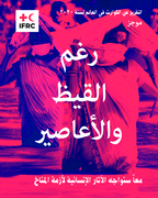
The failure to protect the people most vulnerable to climate change is especially alarming given the steady increase in the number of climate and weather-related disasters. According to the World Disasters Report, the average number of climate and weather-related disasters per d...
Proper and dignified management of the dead in disasters is one of the three key pillars of humanitarian response and a fundamental factor in facilitating identification of the deceased and helping families discover the fate of their loved ones. This second and updated edition of this hugely success...
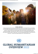
In 2022, humanitarian action will need to adapt to new and challenging realities. The COVID-19 pandemic is taking a heavy toll in developing countries, civilians continue to be the most affected by conflict and extreme poverty is rising. Climate change effects are devastating, forced displacement is...
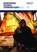
COVID-19 has triggered the deepest global recession since the 1930s. Extreme poverty has risen for the first time in 22 years, and unemployment has increased dramatically. Women and young people aged 15 – 29 working in the informal sector are being hit the hardest. School closures have affected 91...

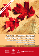
Kaum ein Jahr vergeht inzwischen, ohne dass von neuen Rekorden bei Extremwetterereignissen berichtet wird. Naturkatastrophen und Wetterextreme werden insgesamt immer häufiger und nehmen an Stärke zu – und der Klimawandel spielt dabei eine immer größere und zerstörerische Rolle. Wie schlimm di...

Coordination guidance of in-field disaster management in Indonesia
Accessed 6 March 2019.
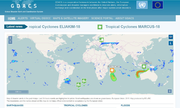
GDACS is a cooperation framework between the United Nations, the European Commission and disaster managers worldwide to improve alerts, information exchange and coordination in the first phase after major sudden-onset disasters
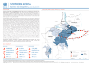
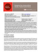
Flooding caused by the Tropical Cyclone Idai weather system since early March has affected nearly 3 million people and caused at least 678 deaths in Malawi, Mozambique and Zimbabwe.
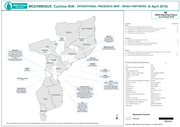
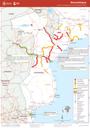
Map that shows the operational presence map and WASH partners in Mozambique
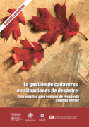
La gestión de cadáveres en situaciones de desastre: Guía práctica para equipos de respuesta
recommended
Segunda edición (revisada). Este manual tiene dos objetivos: en primer lugar, promover la gestión apropiada y digna de los cadavers y, en segundo lugar, facilitar su identificación. Luego de muchos desastres, en particular los de mayor magnitud, la recuperación y la gestión inmediata de los cad...
The Government has declared a national emergency and three days of national mourning starting on 20 March. The official death toll from Cyclone Idai’s landfall has reportedly risen to at least 202 and is expected to increase in the days ahead.Flood waters are predicted to rise significantly in ...
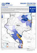
Since the beginning of March 2019, Malawi has experienced flooding and sustained heavy rain caused by the Tropical Cyclone Idai weather system. According to IOM Malawi, 81,613 households (HH) have been affected across four districts in the south of the country, specifically Chikwawa (12,755 HH), Zom...

The official death toll had risen to 493 people as of 29 March, according to the Government.
A new cholera outbreak was reported in Nhamatande; nine Cholera Treatment Centres have been established in Beira and other locations.
More than 140,000 people were displaced in 161 sites across Sofala (116...